Showing posts with label Geographic Information system. Show all posts

Tuesday, May 1, 2012

OPTIKS 4.8.0 - Free Remote Sensing Software


Opticks is an expandable remote sensing and imagery analysis software platform that is free and open source. If you are interested you can learn about the history of Opticks.

If you've used commercial tools like: ERDAS IMAGINE, RemoteView, ENVI, or SOCET GXP, then you need to give Opticks a try. Unlike other competing tools, you can add capability to Opticks by creating an extension. Opticks provides the most advanced extension capability of any other remote sensing tool on the market.


Download :
http://opticks.org/confluence/display/opticks/Downloading+Opticks+4.8.X...?download_url=/opticks/4.8.0/Opticks-4.8.0-32bit.msi


Sunday, April 29, 2012

AutoDEM (create DEM from scanned topographic maps)


AutoDEM (aka as AutoMNT) is a freeware GIS software to create Digital Elevation Models (DEM) from scanned topographic maps for Windows.
Through different data layers (map, contours, DEM, etc.), AutoDEM provides many tools for :

    Topographic map analysis
    Contour lines extraction and reconstruction
    Contours to DEM interpolation and DEM analysis
    DEM to TIN conversion
    Toponyms extraction

Most of the worldwide file formats used in the GIS community are supported. AutoDEM can also directly import data from web servers (TerraServer, WebMapService, WFS, …)

What AutoDEM can do
Here are most relevant features of the software :

    Multi-layers interface to manage original map, extracted contours, elevation grid and triangular mesh.
    Common classical image editing tools (zoom, hand, selection, pen, eraser, lines etc.)
    Support every common image file formats supported by GDAL (JPEG, PNG, PGM, PNM, BMP, GIF …). Complete list
    Support most DEM file formats supported by GDAL. Complete list
    Plug-in based architecture through a DLL mechanism (a Development Kit is coming)
    Contour lines extraction from map through different filters
    Contour lines reconstruction and edition
    Tools to semi-auto set contour lines' elevations
    Contour lines interpolation with different methods like geodesic distances, Partial Differential Equations, Inverse Distance Weighted Averaging, Radial Basis Functions and kriging
    Elevations related tools
    Embossing filter to preview the terrain rendering
    Realtime 3D visualization and navigation with the Level of Detail (LOD) Duchaineau's `Realtime Optimally-Adapting Meshes' (ROAM) algorithm included (need an OpenGL graphic card)
    DEM to regular or irregular (TIN) mesh generation and export
    Import maps and DEM from WebMapFeature (WMS) or TerraServer
    Lot of other features…

As AutoDEM is still a research tool, it's updated very soon and will be developped for many years, and you are encouraged to ask us the improvements you would like to see and help us to make AutoDEM an easy-to-use and powerful tool.


Download :
http://www.autodem.com/download/AutoDEM-v1.6.2b.zip


Friday, April 27, 2012

Surface Water modelling System v10.0.10


 Flexible modeling approaches

Aquaveo pioneered the conceptual model approach. Build a conceptual model in SMS by constructing a high level representation of the model using familiar GIS objects: points, arcs and polygons. Work with large, complex models in a simple and efficient manner by using the conceptual modeling approach and easily update or change the model as needed.

SMS also has powerful tools to build meshes and grids.

Flexible modeling approaches

Aquaveo pioneered the conceptual model approach. Build a conceptual model in SMS by constructing a high level representation of the model using familiar GIS objects: points, arcs and polygons. Work with large, complex models in a simple and efficient manner by using the conceptual modeling approach and easily update or change the model as needed.

SMS also has powerful tools to build meshes and grids.

Import what you need

Models require data from many different sources. That’s why SMS is built to easily import numerous file types:

Raster images including georeference and projection support
Topographical maps & aerial photos
Elevation & bathymetry data
Web data services such as TerraServer
ArcGIS geodatabases and shapefiles
CAD files including .dwg, .dgn, and .dxf formats
Worldwide projection support including Cartesian and Geographic Systems
File Import wizard for delimited text files and spreadsheets

Advanced riverine & coastal modeling

SMS interfaces with a wide range of numerical models for applications including:

Riverine analysis
Contaminate transport
Sediment transport
Particle tracking
Rural & urban flooding
Estuarine
Coastal circulation
Inlet & wave modeling


Download :

Installer :
http://www.aquaveo.com/downloads?tab=2#TabbedPanels

Patch :
http://www.4shared.com/file/IE7q9ZAU/patch.html


Tuesday, April 24, 2012

MapWindow 6.1 Desktop GIS


MapWindow 6 Desktop GIS is an open source desktop GIS for Microsoft Windows that is built upon the DotSpatial Library.

This project is a work in progress. It is actively under development at Idaho State University together with our collaborators. We've constructed a GIS based entirely on Dotspatial and able to be installed, updated, and maintained through the Microsoft ClickOnce system. This should allow users to download and install MapWindow 6 on any Windows computer - even without administrator privileges (e.g. in a computer lab setting).

If you are a developer, you can create extensions for MapWindow 6 in C# or VB.NET by using the DotSpatial Library.

The Open Source MapWindow GIS project team also manages a widely used desktop GIS application, MapWindow 4.x which is hosted at www.MapWindow.org. Source code for MapWindow 4 is on the MapWindow 4 CodePlex site. The MapWindow project includes an end user desktop application that is extensible through the writing of plugins written in .NET, as well as an ActiveX control project called MapWinGIS.ocx. This project has been highly successful and continues to grow through adoption and contributions by individuals, companies, agencies, etc.

If you need a stable free GIS for Windows, please use MapWindow 4. If you want to try a work in progress and/or help develop the .NET only version of MapWindow, then please download MapWindow 6.

Key features of MapWindow 6 Alpha Desktop GIS

    Fully .Net Managed Code (no COM registration or admin installation)
    Vastly extended symbology set
        Stacks of Symbols
        Schemes based on attributes
        Point decorations
        Symbols from scalable system fonts
    Object Oriented Code
        Perform overlays, intersections, directly with features.
        FeatureSet.DataTable is a System.Data.DataTable.
        OGC Geometries
    Comprehensive Plug-in Model
        Plug-in interfaces have events like normal objects
        Control virtually everything directly through the plug-in interface


Download :
http://download.codeplex.com/Download?ProjectName=mapwindow6&DownloadId=357914&FileTime=129769284938430000&Build=18696


Sunday, April 22, 2012

MSP Geotrans 3.2 Geographic Translator


Geotrans 3.2 has been released. Geotrans is the coordinate conversion application or a geographic translator program among a wide variety of coordinate systems, map projections, and datums. Geotrans runs in Microsoft Windows, LINUX and UNIX environments. GEOTRANS can also be used to convert large numbers of coordinates contained in either text files (.txt) or comma separated values (.csv).

To convert a set of coordinates, simply select the coordinate system or map projection, the datum, in which your coordinates are defined, then enter the source coordinates, select the coordinate system or map projection, and the datum, to which you want the coordinates to be converted, and click on the Convert button. The resulting coordinates will be displayed.

 Download :
http://earth-info.nga.mil/GandG/geotrans/geotrans3.2/install.exe


Saturday, April 21, 2012

Eye4Software GPS Mapping Studio


 The Eye4Software GPS Mapping Studio, is a professional GPS/GIS mapping software tool, which can be used in numereous applications.

You can use the software to import- and export, convert, view and edit your maps or to display your position. Using the built in track recorder, you can also record all your movements when a GPS receiver has been connected.

The software will work with almost any (NMEA0183 compatible) GPS receiver, and can be used on any desktop, laptop or netbook computer running Windows XP SP2 or higher.

Some application examples:

    Add comments, symbols, tracks, waypoints or routes to your maps;
    Transfer GPS data like tracks, waypoints and routes, from or to your Garmin GPS device;
    View GIS features of vector data;
    View maps containing elevation or depth data;
    Edit waypoints, tracks and routes;
    Show your current position on a map;
    Convert GPS data between different file formats;
   Convert vector maps to AutoCAD DXF, Keyhole Markup Language, ESRI Shape, GeoRSS,         GeoJSON, ARC Generate or Atlas BNA format;
    Convert vector maps from one map projection to another.
    Perform realtime positioning on vessels, cars, trucks and construction vehicles;
    Record your current position and movements, for instance to get hold of the covered area or track;
    Load previously recorded track-and-trace data for further analysis;
    And many more...


Download Trial :
http://www.eye4software.com/files/gpsmapping/setup.exe


Quick Terrain Modeler


 Quick Terrain Modeler is the world’s premier 3D point cloud and terrain visualization software package.  Designed for use with LiDAR, but flexible enough to accommodate other 3D data sources, Quick Terrain Modeler provides an easy to use software experience that allows users to work with significantly more data, render larger models, analyze data faster, and export a variety of products.  These benefits enable very powerful, yet simple and intuitive, terrain exploitation.


With the release of Quick Terrain Modeler Version 7.1.0, draping huge 2D images (GeoTIFF's, MRSID, ECW, etc.) on 3D point clouds and DEM's - and even permanently sampling them into the points/vertices to create colorized 3D products - has never been easier. The images below show a standard height-colored point cloud, and the same point cloud with RGB values sampled from 2D imagery.


Download Trial :
http://www.appliedimagery.com/qtmtrial.php


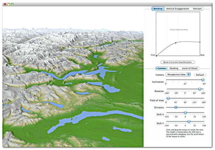
Terrain Bender 1.0 (Progressive Bending 3D Maps)


3D maps with progressive bending show the landscape using a varying viewing angle from steep in the foreground to flat in the background. The result is similar to the way in which passengers in a plane perceive the landscape, first looking straight downwards and then raising their gaze towards the horizon.

With progressive bending, 3D maps gain display depth, and landscape elements in the foreground are less obstructed from view than on 3D maps using a central perspective.

Terrain Bender Features :
Terrain Bender offers specialized tools for bending terrain models.

    progressive bending
    curved horizon bending
    vertical exaggeration adjustable in foreground and background
    preview with perspective camera, parallel camera, and 360° cylindrical panoramas
    illumination settings
    hypsometric tinting, haze simulation, and texturing
    import and export of terrain models in ESRI ASCII grid file format

Terrain Bender features interactive previews of 3D maps, but final rendering is best done with ray-tracing software.


Download :

32 bit : http://www.terraincartography.com/terrainbender/TerrainBenderWin32Bit.zip

64 bit : http://www.terraincartography.com/terrainbender/TerrainBenderWin64Bit.zip


WinTopo Pro (Raster to Vector Conversion)


WinTopo Pro converts images from scanners and other digital sources into vector data suitable for CAD, GIS and CNC systems. You can scan old plans, archive drawings, or even photos and convert them into useful CAD data. Any image which is stored in TIFF, GIF, JPEG, PNG or BMP format can be processed by WinTopo Pro into DXF and other vector file formats.

WinTopo Pro builds upon the powerful WinTopo Freeware by including many additional image processing tools, as well as more advanced vectorisation algorithms and options.

This highly professional product is the software of choice of major industries worldwide. Our customers include NASA , Microsoft, MIT, British Telecom, BAE Systems, Motorola, EDS, and many branches of the US Department of Defence.

We believe that you should decide for yourself by trying it out on your own computer. So please do download and install the software. You can use all the functions and options, excepting that you need a license to save the full result (a sample of the vector result can be saved in non-licensed mode).

WinTopo Pro is priced to be affordable. However, it is a high quality product which produces high quality results.


Download :
http://www.wintopo.com/download/setup-wintopo-pro.zip

VSceneGIS (Analysis, Computation and GIS editing)


About Project VSceneGIS

VSceneGIS project is based on the old project Visual Scene 1997-2004,developed by Antonio Mª Piña Valls.

Current projects in development:

-  VSceneGIS Desktop. Customer Project Development, Analysis, Computation and GIS editing. VSceneGIS platform, applies the concept of Tree and Graph Topology to implement the data model in GIS.

- API for GIS applications development.

VSceneGIS intended to be a development under the GNU/GPL implemented in Java, currently functional in the JRE 1.6_23, and the current phase of the project uses the libraries for access to WMS, WFS Geootols, and Common Open Layers JideSoft for the creation of VSceneGIS Desktop CheckBoxTree implemented.

 Download :

Release VSceneGIS Desktop 0.9.2. Update 2 :

http://downloads.sourceforge.net/project/vscenegis.u/VSceneGISDesktop0_9_2u2.exe?r=http%3A%2F%2Fvscenegis.com%2Findex.php%3Foption%3Dcom_jdownloads%26Itemid%3D42%26view%3Dfinish%26cid%3D4%26catid%3D3%26m%3D0%26lang%3Des&ts=1327118430&use_mirror=nchc


Mapwel 2012 - Software for creation of custom GPS maps


All-in-one software for creation of custom GPS maps compatible with Garmin GPS units. Mapwel supports routing, ESRI shapefiles, OpenStreetMap OSM, Google Earth KML and KMZ, cGPSmapper MP and GPX files. Mapwel custom GPS mapping capability and user icons editor are often used in forestry, electrical engineering, geology and geodesy. Creation of a GPS map involves georeference of raster images, drawing of the vector map, import of data from various file formats and online sources, conversion of the map data into the native format of the GPS and upload of that data into the GPS. Mapwel is the only available mapping software compatible with Garmin GPS units that allows the user to do the all above steps with a single software tool. Mapwel uses its own map compiler.English
 
Download :
http://www.mapwel.eu/download/mapwlstp.zip


ENVI Image Analysis For ArcGIS


ENVI Image Analysis Tools Now Available in ArcGIS®

In the past, updating a GIS with valuable information obtained from geospatial imagery required multiple tools. With ENVI 4.8, image analysis capabilities are fully integrated with ArcGIS, eliminating the need to switch between software packages.

ENVI 4.8 completes the integration with ArcGIS from Esri – delivering for the first time, advanced image processing and analysis tools directly from the ArcGIS desktop and ArcGIS® Server environments. Because ENVI 4.8 is completely compatible with ArcGIS 10 and 9.3, you can now include imagery in your workflow while taking advantage of the latest technology that Esri has to offer.

The new ENVI tools for ArcGIS are available in a familiar ArcGIS toolbox, exposing ENVI functionality through geoprocessing scripts that operate in both desktop and server environments. ENVI provides you with nearly 20 pre-built tools to easily perform a variety of advanced image processing and analysis tasks without leaving ArcGIS, allowing you to:

    * Detect change over time
    * Find and extract features of interest
    * Classify features or land cover
    * Identify anomalies

Above you can see the ENVI tools within the ArcToolbox. The image in this scene is the result of running an ENVI image analysis tool designed to calculate the differences between images.

For ArcGIS® Server users, ENVI tools can also be delivered to your entire organization using the newest addition to the ENVI product line, ENVI for ArcGIS® Server.

Easily Add LiDAR Data to Your Workflow

Geospatial information comes in a variety of formats, all of which help to build a complete picture about a geographic area. With ENVI 4.8, you'll have the tools you need to combine different data sources and the information they provide to piece together a complete picture of an area of interest.

ENVI 4.8 introduces the LiDAR viewer, extending the existing ENVI LiDAR functionality by adding a high performance, 3-dimensional viewer that efficiently works with very large LiDAR data sets. And, with the ability to quickly and easily display point clouds in a variety of colors and ranges, the new LiDAR viewer will help you visually interpret your data and give you a more complete understanding of a particular area of interest.

The new ENVI LiDAR viewer allows you to display point clouds in a variety of colors and ranges.
       

Use the ENVI LiDAR viewer to:

    * Filter by return, elevation, or point classification
    * Display your data with a variety of surface types
    * Measure height or volume of any structure
    * Add custom color palettes


And, with the high performance ENVI LiDAR viewer, you can easily underlay a satellite or airborne image with your LiDAR display to create important situational awareness.


New Automated Workflow for Viewshed Analysis


In recent releases, ENVI introduced automated workflows to make a variety of tasks less labor intensive. ENVI workflows deliver scientifically proven methods for processing and analyzing imagery in step-by-step, wizard-like processes that make advanced functionality available to users of any experience level.


The new viewshed analysis workflow in ENVI 4.8 guides you through the multi-step process of viewshed analysis, providing you with the information you need to make important tactical decisions, such as where to strategically place a cell tower for maximum coverage, determining the safest path for troop movement, or identifying out-of-sight locations for concealing landfills and wastewater treatment centers. The ENVI viewshed workflow allows you to easily exploit a DEM and determine visible areas from a variety of view sources, including points, lines, or polygons, so you can easily:

    * Export results directly to raster, vector, or an ArcGIS geodatabase
    * Define multiple, simultaneous viewshed points, polylines, or polygons
    * Determine viewshed and viewrange independently


Download :

ENVI 4.8 :
http://www.6ybh-upload.com/0h02eol8342q/envi48win32_setup.7z

ENVI EX 4.8 :
http://www.rayfile.com/files/cc115907-fba5-11df-96ec-0015c55db73d/


Cracking License.dat :

####################### LICENSE.DAT #######################
############ license file comments, do not delete ###############
# License Number(s):91690
SERVER dicom 00e0815cb40f 1700
USE_SERVER
DAEMON idl_lmgrd
INCREMENT envi idl_lmgrd 4.800 1-jan-0000 19 B8475B9E3DB5D173 \
VENDOR_STRING=”91690Imaging Labs, RRI” ck=94 SIGN=”0CDA 5168 \
030F EAC5 D335 7EC7 3E2D 87D9 1601 2D37 2D6F 93A5 384B E39D \
A927 0EDD C6FB 0BA4 A9A5 1539 BE92 FFC3 AC0E 7BFB 45B5 E162 \
83C7 2985 1976 BBF9?
INCREMENT envi_cartosat idl_lmgrd 4.800 1-jan-0000 19 \
2890CDFE3E6B6052 VENDOR_STRING=”91690Imaging Labs, RRI” ck=124 \
SIGN=”154B FC6F D966 F714 CF9A 13A2 D3D7 5238 E7B4 6C81 38E8 \
E87F 4168 7E9B 9236 104E 22D6 5AD4 97BF E041 FFFC 6C75 6673 \
A44B 8C9B 9406 52B8 5245 AD7B EF39?
INCREMENT idl idl_lmgrd 8.000 1-jan-0000 190 BE647A46C540CDAC \
VENDOR_STRING=”91690Imaging Labs, RRI” ck=131 SIGN=”07F8 47AD \
4AD6 5240 2C6C F415 7AC5 D248 C960 EEFD C2AB 7EAC 9987 5675 \
C441 19E5 5D15 61DB 7AA4 B9DE 0CD0 6A17 B163 F77E 931C 8A3C \
0B48 2618 9074 7E5B”
INCREMENT idl_bridge_assist idl_lmgrd 8.000 1-jan-0000 19 \
69ABAF9502800882 VENDOR_STRING=”91690Imaging Labs, RRI” ck=68 \
SIGN=”0B69 0B17 96D2 D30A F3E8 F5A7 1F7F 52C9 2823 7571 2423 \
BD64 60D2 6098 ED72 0413 5921 F9E7 0CB2 0791 2425 408C 1B86 \
1C2D 9857 58B8 30DE 5C13 CA3E 60B7?
INCREMENT idl_wavelet idl_lmgrd 8.000 1-jan-0000 19 6E7671FC3E09A7F9 \
VENDOR_STRING=”91690Imaging Labs, RRI” ck=88 SIGN=”1C0C 81E6 \
29E1 B654 E4E9 0E56 91B5 A633 07B0 6DD5 542C A764 532F 2534 \
3700 1923 3DBC 3F46 90FD 4045 963E EE61 9BEC 6E0F CAD3 F098 \
984D 57DE E961 259B”
FEATURESET idl_lmgrd ECEA60334B9C3CBE
##################### end of license file #######################
###########################################################


How to Cracking :
LICENSE save the above text, with "computer " were replaced by the fourth line "dicom", the card's "MAC address " the fourth line replace the string host name followed by "00e0815cb40f". Import the use of LICENSE WIZARD LICENSE, the process starts LMTOOLS, check the parameter setting, preferably in the START / STOP / REREAD tab REREAD it.

GPSMap Edit 1.1 (GPS BaseMap Maker)


This software is designed for visual authoring of GPS-maps in various cartographic formats:

- Polish format,
- Garmin MapSource,
- Lowrance MapCreate,
- Navitel Navigator (navigation software for Windows Mobile, Android, Symbian, iPhone),
- ALAN Map 500/600, Holux MapShow,

And custom POIs and speedcams for:

- Garmin POI Loader · iGO · TomTom OV2 · Navitel Navigator.

The program may also load and convert GPS-tracks, waypoints and routes in various formats:

GPX · KML · Garmin · iGO 8 · iGO Primo · Lowrance · Magellan · Nokia · OziExplorer · ALAN · Holux.

Other supported formats are:

ECW · JPEG 2000 · JPG · BMP · GIF · PNG · TIFF · EXIF · Google Maps · ESRI shapefile · MapInfo MIF/MID · CSV · XLS · DBF · MDB ·


Download :

For Make Basemap, not only GPS Map Edit tool.. but you need cGPSMapper and MapUpload too.
So, download this third software :
 
GPSMap Edit     : http://www.geopainting.com/download/mapedit1-1-73-2-setup.exe
cGPSMapper     : http://cgpsmapper.com/download2/ProSetup.exe
MapUpload        : http://www.mapwel.net/download/mapupload.exe


TatukGIS Editor


The TatukGIS Editor is a general purpose GIS desktop mapping and data editing application that is fully customizable and extendable using powerful built-in scripting tools. The design philosophy of this product is to provide powerful functionality with almost unlimited potential in an application that is still easy to learn and use without expensive training. To avoid menu clutter, the default user interface is limited to features that are most used and valued, implemented in an intuitive manner appreciated by most users. Specialized features are reserved for custom implementation, in the way that exactly fulfills the customer requirements, using scripts. The default user interface includes:


Viewing

Opens most vector, image, grid, and SQL geodatabase file types, including advanced spatial databases, e.g., Microsoft SQL Spatial, Oracle Spatial & Oracle GeoRaster, ESRI ArcSDE & ArcSDE Raster, MapInfo SpatialWare, IBM DB2 Spatial Extender, IBM Informix Spatial Datablade, and PostGIS. Web Map Tiles and WMS layers can be opened from the web. Each layer type is supported “natively”, without any import operation or format conversion. Comprehensive visual layer property and legend controls provide for deep customization of the appearance of each map layer, thematic mapping, layer hierarchies, legend presentation, scale… Other features include SQL Query Builder, advanced selection tools, and attribute data grid table.
3D Viewing

3D vector rendering, DTM model presentation, automatic draping of image and 2D vector layers over DTM models, flood simulation, light & shadow control, powerful camera/scene control...
Coordinate systems

Nearly 3,000 pre-defined coordinate systems (including all U.S. State Planes), user defined coordinate systems, on-the-fly vector/raster map layer reprojection, export to any coordinate system, and automatic layer coordinate system recognition. Support reflects WPSG codes and OGC WKT definitions.
Editing

Create, edit, translate, export, save GIS map files or selected data to a number of vector, raster, grid, and SQL geodatabase formats, including advanced spatial database data structures. Topology builder/corrector feature systematically clears geometry related errors (overlapping polygons, holes between polygons, missed line intersections, dangling nodes, etc.) from vector line or polygon layers.
Scripting

Powerful built-in scripting IDE for writing and debugging code can be used to modify the Editor, including full menu redesign, custom dialog boxes, etc. or to extend the Editor with additional features. The scripting engine exposes (inside the Editor) the full power of the TatukGIS Developer Kernel, with its object API composed of 2,200+ functions and properties, to fulfill the requirements of any kind of GIS application. Scripted customizations or new features are easily deployed to other Editor users. Product is provided with dozens of example Pascal and Basic scripts.
Databases

Supporting most database engines, e.g., Microsoft SQL Server, Oracle, IBM DB2, IBM Informix, Interbase, Firebird, PostgreSQL, SQLite, MSJET..., most spatial and non-spatial database map layer formats, and live joins of vector maps to external databases.

The free TatukGIS Viewer is a slimmed down version of the Editor, without the data editing, customization, and 3D viewing features. Both products feature 16 user interface language options.

Download :
http://www.tatukgis.com/

AutoCAD Map 3D 2012


AutoCAD® Map 3D Enterprise mapping software is a model-based infrastructure planning and management application that provides broad access to CAD and GIS data. With intelligent industry data models and tools, you can apply regional and discipline-specific standards. These technologies help you improve data quality, support productivity, and better manage infrastructure assets. While working in a single, familiar AutoCAD-based environment.

Features
AutoCAD® Map 3D GIS mapping software offers easier access to design, GIS, imagery, point cloud, and business information from a broad range of sources, including Esri, Bentley, Oracle, GE, and other software providers. By using comprehensive data models for the gas, water, wastewater, and electric industries, you can organize disparate asset information and apply industry standards and business requirements to your data.

Download Full :
http://www.wupload.com/file/8199600/AUTODESK.AUTOCAD.MAP.3D.V2012.32-ISO.part01.rar
http://www.wupload.com/file/8199601/AUTODESK.AUTOCAD.MAP.3D.V2012.32-ISO.part02.rar
http://www.wupload.com/file/8199603/AUTODESK.AUTOCAD.MAP.3D.V2012.32-ISO.part03.rar
http://www.wupload.com/file/8199604/AUTODESK.AUTOCAD.MAP.3D.V2012.32-ISO.part04.rar
http://www.wupload.com/file/8199605/AUTODESK.AUTOCAD.MAP.3D.V2012.32-ISO.part05.rar
http://www.wupload.com/file/8199606/AUTODESK.AUTOCAD.MAP.3D.V2012.32-ISO.part06.rar
http://www.wupload.com/file/8199607/AUTODESK.AUTOCAD.MAP.3D.V2012.32-ISO.part07.rar
http://www.wupload.com/file/8199608/AUTODESK.AUTOCAD.MAP.3D.V2012.32-ISO.part08.rar
http://www.wupload.com/file/8199609/AUTODESK.AUTOCAD.MAP.3D.V2012.32-ISO.part09.rar
http://www.wupload.com/file/8199610/AUTODESK.AUTOCAD.MAP.3D.V2012.32-ISO.part10.rar
http://www.wupload.com/file/8199611/AUTODESK.AUTOCAD.MAP.3D.V2012.32-ISO.part11.rar
http://www.wupload.com/file/8199612/AUTODESK.AUTOCAD.MAP.3D.V2012.32-ISO.part12.rar
http://www.wupload.com/file/8199613/AUTODESK.AUTOCAD.MAP.3D.V2012.32-ISO.part13.rar
http://www.wupload.com/file/8199614/AUTODESK.AUTOCAD.MAP.3D.V2012.32-ISO.part14.rar
http://www.wupload.com/file/8199615/AUTODESK.AUTOCAD.MAP.3D.V2012.32-ISO.part15.rar
http://www.wupload.com/file/8199616/AUTODESK.AUTOCAD.MAP.3D.V2012.32-ISO.part16.rar
http://www.wupload.com/file/8199617/AUTODESK.AUTOCAD.MAP.3D.V2012.32-ISO.part17.rar
http://www.wupload.com/file/8199618/AUTODESK.AUTOCAD.MAP.3D.V2012.32-ISO.part18.rar
http://www.wupload.com/file/8199619/AUTODESK.AUTOCAD.MAP.3D.V2012.32-ISO.part19.rar
http://www.wupload.com/file/8199620/AUTODESK.AUTOCAD.MAP.3D.V2012.32-ISO.part20.rar
http://www.wupload.com/file/8199621/AUTODESK.AUTOCAD.MAP.3D.V2012.32-ISO.part21.rar
http://www.wupload.com/file/8199622/AUTODESK.AUTOCAD.MAP.3D.V2012.32-ISO.part22.rar
http://www.wupload.com/file/8199623/AUTODESK.AUTOCAD.MAP.3D.V2012.32-ISO.part23.rar
http://www.wupload.com/file/8199624/AUTODESK.AUTOCAD.MAP.3D.V2012.32-ISO.part24.rar
http://www.wupload.com/file/8199625/AUTODESK.AUTOCAD.MAP.3D.V2012.32-ISO.part25.rar
http://www.wupload.com/file/8199626/AUTODESK.AUTOCAD.MAP.3D.V2012.32-ISO.part26.rar
http://www.wupload.com/file/8199627/AUTODESK.AUTOCAD.MAP.3D.V2012.32-ISO.part27.rar
http://www.wupload.com/file/8199628/AUTODESK.AUTOCAD.MAP.3D.V2012.32-ISO.part28.rar
http://www.wupload.com/file/8199629/AUTODESK.AUTOCAD.MAP.3D.V2012.32-ISO.part29.rar
http://www.wupload.com/file/8199630/AUTODESK.AUTOCAD.MAP.3D.V2012.32-ISO.part30.rar

Installation:
Unpack, burn or mount with D-Tools & install.
Check c/r/a/c/k/install.txt on DVD1
No Lame Patching, no problems with updates, no problems exporting to a "legal" version, no trial patched, no files modified etc ... The one and only way to do it - k/e/y/g/e/n - fully activated
Enjoy!

Global Mapper 13


Overview
         
Global Mapper is more than just a utility; it has built in functionality for distance and area calculations, raster blending, feathering, spectral analysis and contrast adjustment, elevation querying, line of sight calculations, cut-and-fill volume calculations, as well as advanced capabilities like image rectification, contour generation from surface data, view shed analysis (including Fresnel) from surface data, watershed delineation, terrain layer comparison (including differencing), and triangulation and gridding of 3D point data. Repetitive tasks can be accomplished using the built in scripting language or comprehensive batch conversion functionality.        
           
Have you ever received a dataset that does not match the projection of your current project? Simply load the dataset into Global Mapper, change the projection, and save the file to match your coordinate system. If the dataset is larger than the area you are interested in, export the data using the crop feature and change the projection and format of the data at the same time.          
           
Your data files can be loaded as layers, for example a Digital Elevation Model (DEM) can be loaded with a scanned topographical map to create a 3D view of the map. A digital aerial image can be draped on the surface together with vector contour mapping to create a stunning and informative graphic. The results can be printed, or the workspace can be exported to a high resolution raster image for use in a presentation or report.


Download :
http://ge.tt/92hgan7?c


Friday, April 20, 2012

SuperGIS Desktop 3.1


SuperGeo Technologies announces that the latest desktop GIS product—SuperGIS Desktop 3.1 Beta is released.

 According to the announcement, SuperGIS Desktop 3.1 is based on the brand new SuperGIS Engine 3 and provides more various GIS tools and assists GIS professionals in efficiently displaying, editing, managing and analyzing spatial data. It also improves the performance and provides numerous editing tools.

Supergeo reports that SuperGIS Desktop 3.1 provides two editions, Professional and Standard. Besides covering the functions of Standard edition, Professional edition also supports topology analyst, enforces geodatabase management, and provides VBA customization. SuperGIS Desktop 3.1 also provides a number of new editing tools such as, Segment Deflection, Finish Square Sketch, Direction-Distance tool, Distance-Distance tool, Reshape Feature, parallel, Split at Vertex tool, Generalize Tool, Smooth Tool, etc. These tools can help improve users’ editing efficiency.

Topology analyst supports to validate and display topological relationship for spatial dada and assists users in effectively editing and fixing maps, according to the announcement. In geodatabase management, it supports to read and edit the vector data in database. Moreover, the built-in VBA customization tools allow users to develop the GIS tools by themselves to build their own GIS platforms.

Free Trial Download

Desktop GIS
SuperGIS Desktop 3.1 Professional(2012/04/12) 214,058 KB
SuperGIS Desktop 3.1 Standard(2012/04/12) 214,058 KB
SuperGIS Network Analyst 3.0(2012/04/12) 9,964 KB
SuperGIS Spatial Analyst 3.0(2012/04/12) 13,999 KB
SuperGIS Desktop 3.0(2011/03/30) 135,497 KB
SuperGIS 3D Analyst 2(2010/09/13) 15,179 KB
SuperGIS Biodiversity Analyst 2(2010/08/13) 2,876 KB
SuperGIS Spatial Statistical Analyst 2(2010/08/13) 3,761 KB
 
Sumber :
http://www.supergeotek.com 

ArcGIS 10.1 Beta 2


ESRI telah merilis ArcGIS 10.1 pada awal tahun 2012. Untuk itu ESRI mengubah penamaan di ArcGIS karena faktanya, bagaimanapun ArcGIS digunakan, pada dasarnya menggunakan sistem yang sama.

 Berikut beberapa perubahan nama menyusul rilis ArcGIS 10.1 :
Name Prior to ArcGIS 10.1 New Name
ArcGIS Desktop ArcGIS for Desktop
ArcInfo ArcGIS for Desktop Advanced
ArcEditor ArcGIS for Desktop Standard
ArcView ArcGIS for Desktop Basic
ArcGIS Server ArcGIS for Server
ArcGIS Mobile ArcGIS for Windows Mobile
ArcGIS Mobile SDK ArcGIS SDK for Windows Mobile
Esri Data and Maps Data and Maps for ArcGIS
Esri StreetMap Premium StreetMap Premium for ArcGIS
ArcGIS Data Appliance Data Appliance for ArcGIS
ArcGIS Mapping for SharePoint ArcGIS for SharePoint

ArcGIS 10.1 bertemakan Sharing and Collaboration, dimana pengguna akan menemukan bahwa versi ini akan lebih memudahkan  untuk analisis geospasial dan pemetaan pada lebih banyak pengguna tanpa pengguna tersebut harus ahli dalam GIS. ArcGIS user akan dapat membagi semua sumber daya GIS, seperti peta, citra, geodatabases, dan berbagai macam tools dan script, sebagai sebuah layanan web, sehingga sumber daya GIS bisa lebih banyak dimanfaatkan oleh orang yang membutuhkan. Kemampuan untuk mengakses layanan ini akan dibangun di dalam ArcGIS, dan dengan  aplikasi yang dibangun dengan menggunakan ArcGIS API. di ArcGIS 10.1, Python menjadi pondasi untuk ArcGIS,  hal ini untuk menjembatani kesenjangan antara analis GIS dan programer.
Baca tentang ArcGIS 10.1 di ArcNews pada laman The Road Ahead for ArcGIS. ArcGIS 10.1 sudah di agendakan pada ESRI International User Conference untuk dibuatkan sesi Technical Workshops pada bulan depan. Selengkapnya tentang workshops tersebut Anda bisa lihat pada laman ini.

 Sumber :
http://www.inigis.com